Tools
An introduction to the federal survey framework used in the historical records, the 1876 township plat, and the questions the available sources leave open.
Survey framework, not a present map#
Historical deeds use Township 2 South, Range 3 East, Humboldt Meridian. That is a Public Land Survey System description: a shared federal-survey framework that helps locate the language of old records. It is not a present ownership map or a present boundary determination. [1]
The verified 1872–1876 sequence#
- 1872: court discussion identifies John M. Ingalls’s exterior-line work.
- 1874 and 1875: the court accounts contain both dates for S. W. Foreman’s work or a relevant corner.
- 11 January 1876: the subdivisional plan was approved.
- 18 January 1876: the plan was filed at the Eureka land office.
The dates should not be smoothed into a single asserted survey date. The available sources do not identify whether each refers to field work, monumenting, submission, approval, or filing. [2]
The 1876 township plat#
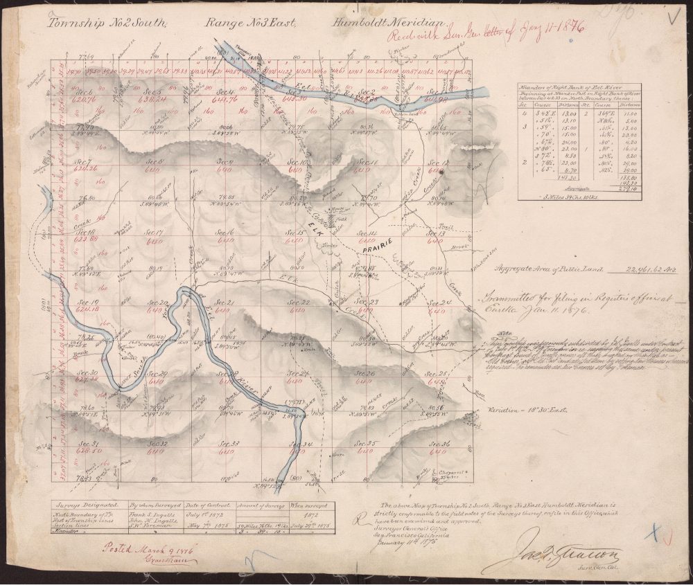
Township 2 South, Range 3 East plat#
What the record shows: the township-and-section framework used by later historical descriptions.
Why field notes and natural calls matter#
Weaver v. Howatt discusses the use of Foreman’s map and field notes, including natural-object calls, while addressing historical survey evidence. It is useful archival context for understanding why original plats and field notes matter. This archive does not apply the case to a present boundary. [3]
The National Archives’ Record Group 49 guide identifies Humboldt Meridian township maps maintained by the Eureka land office. The precise T2S R3E field-note and plat references still require archival confirmation.
Reading a federal land description#
- Humboldt Meridian
- The principal-meridian reference for this federal survey system.
- Township
- A six-mile-square survey unit.
- Range
- A north–south survey column measured from the meridian.
- Section
- One of 36 numbered divisions in a township.
- Quarter-section
- A smaller aliquot subdivision used in historical descriptions.
How the survey framework helps historical research#
The survey notation links documents that may describe the same broad historical area in different ways. A road name, a nearby community name, and a township description are not equivalent labels. The Jay Smith Road geographic overview introduces Myers Flat, Miranda, and the Humboldt Redwoods region; the township description supplies the survey vocabulary used in the historical records.
Township, range, and meridian together#
Read “Township 2 South, Range 3 East, Humboldt Meridian” as a complete reference. The township and range numbers depend on the named survey system. Removing the meridian loses an essential part of the description. A section number then selects a smaller division within that township. The BLM land-description guide explains this general system using examples from Oregon and Washington; those examples use the Willamette Meridian rather than Humboldt Meridian.
The plat and later records#
The 1876 township plat, 100 UR 445, is the library's map source for the historical framework. The 1947 proposed road map has a different documentary purpose. Reading them together requires identifying what each actually depicts, instead of placing a present roadway or ownership outline onto the earlier survey.
Why several survey dates can remain relevant#
The existing chronology distinguishes exterior-line work, discussions of Foreman's work or a corner, and approval and filing dates for the subdivisional plan. The library preserves the 1874/1875 uncertainty in the accounts it cites. Resolving that question would require checking the original evidence and what each date refers to; selecting a single year for a cleaner timeline would obscure the issue.
Archival leads and useful citation details#
The National Archives guide to Record Group 49 lists Humboldt Meridian township maps maintained by the Eureka land office. This is a description of an archival collection, not confirmation that a particular item has been inspected. The precise reference for the relevant original plat and field notes remains a research task.
When documenting a future archival finding, retain the repository, collection or record group, series, item title, date, and available file or box reference. A reproducible citation helps another reader locate the same material. If a document's identity or date is uncertain, preserve that qualification in the research notes.
The source register retains the historical court-publication citations already used by this article as survey research leads. Their use here is documentary and historical; this library does not apply those cases to a present property or boundary question.
Related research: maps and survey sources, the historical timeline, and the homepage survey overview.
1853: Henry Washington and the Humboldt initial point#
BLM’s A History of the Rectangular Survey System dates the Humboldt initial point to 6 October 1853 and identifies Colonel Henry Washington as the surveyor who established it on Mount Pierce. The initial point anchored a separate meridian and baseline for surveys in northwestern California.
The account describes severe practical obstacles: rugged country, thick brush, and timber made the work expensive and difficult. It reports that survey contracts were hard to obtain at the authorized per-mile rate. Establishing a reference point therefore did not mean that the surrounding landscape was promptly or uniformly surveyed.
The cited history describes the chosen summit as difficult to reach. It does not, in the passage used here, establish a complete decision record explaining why that particular summit was selected over alternatives. Original correspondence and survey instructions would be needed for a fuller account.
California’s principal meridian systems#
The BLM California meridians guide distinguishes Humboldt in the northwest, Mount Diablo across much of northern and central California, and San Bernardino in the south. The named meridian is an essential part of a historical township-and-range reference.
Original conceptual diagram. The boxes compare survey systems; their sizes and positions do not depict jurisdictional boundaries.
Explore the Humboldt Meridian research center#
- How to read township, range, section, and aliquot parts — with an interactive schematic section grid.
- Surveying in redwood country — field work, chains, records, corners, and physical evidence.
- From original survey to modern GIS — an explanation of different record systems.
- Eureka land-office archival sources — the National Archives collection guide.
- Survey instructions and cadastral publications — a source gateway for terminology and practice.
The source explorer includes a Humboldt Meridian topic. The historic maps library retains the 1876 township plat and links to the educational material without presenting a schematic as official geometry.